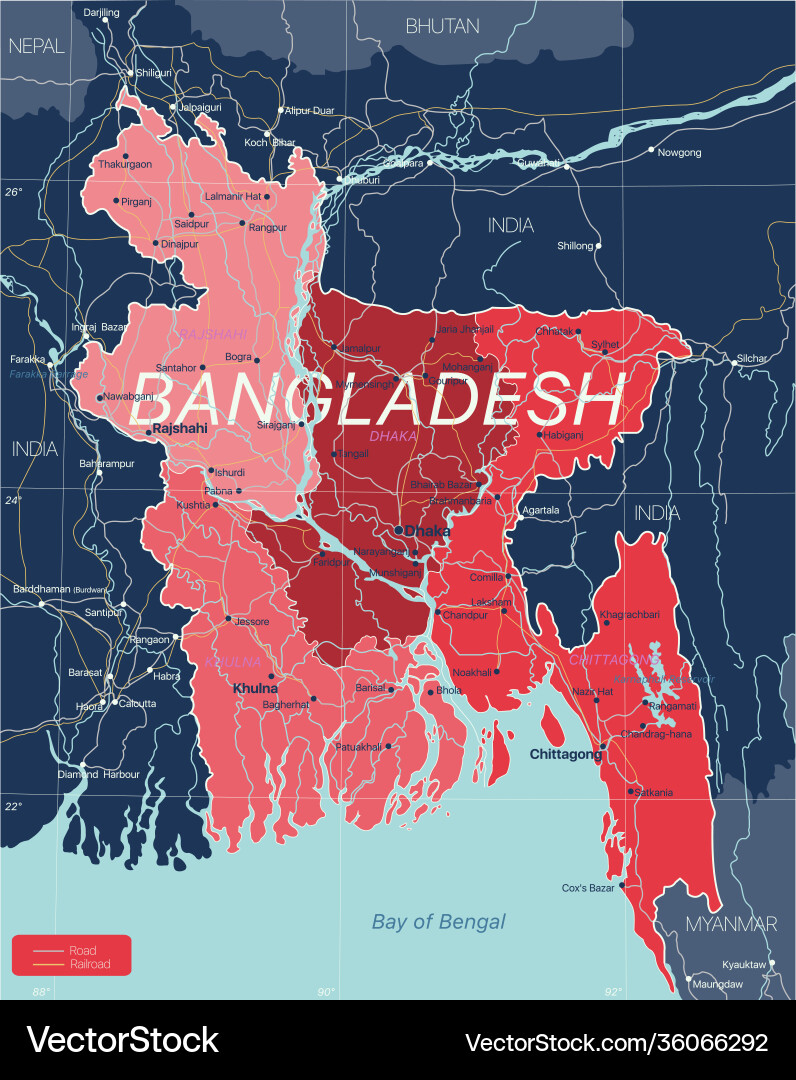
It wasn’t only the politics that challenged Bangladesh. Already before its independence, it was a poor country, and whatever was economically generated, was siphoned off by West Pakistan, at the time. The nine months Liberation War didn’t help, and besides, Bangladesh’s location at the mouth of several big rivers, like the 3000 km long Brahmaputra and the only mildly shorter Ganges, that together form an impressive delta in front of the Bay of Bengal, makes it prone to frequent floodings – the average elevation in most of the country is no more than 10 m!

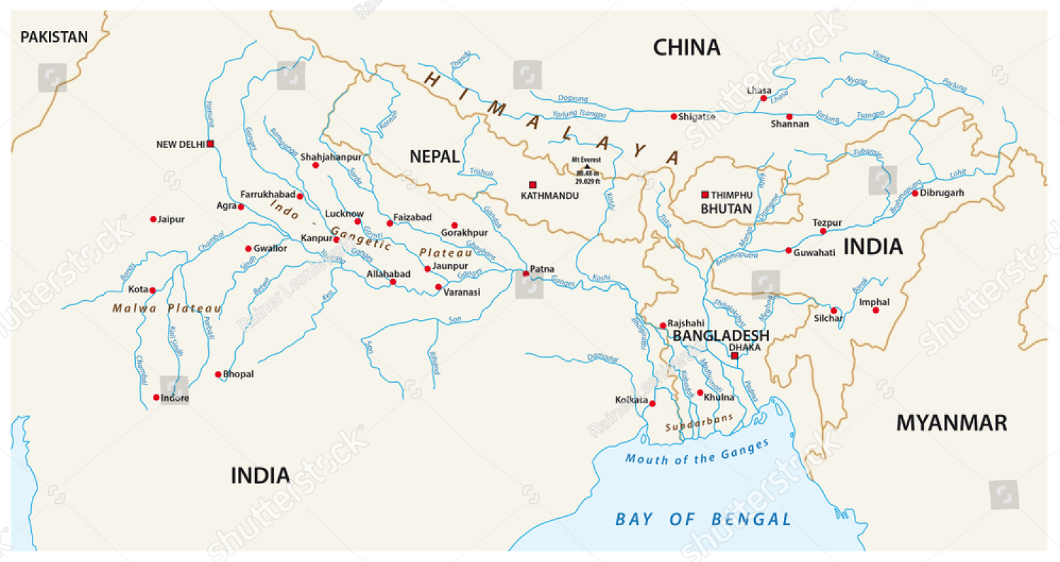
there is an impressive anetwork of rivers ending up in the Bay of Bangal just in front of Bangladesh

Add to that the frequent occurrence of storms and cyclones which have a devastating effect on life and lives: in 1970 Cyclone Bhola killed an estimated 300,000 to 500,000 people, making it the deadliest tropical cyclone on record, in 1988 the country experienced one of the most devastating floods in its history with almost 60% of the country, including much of the capital Dhaka, submerged, a cyclone 1991 was responsible for the deaths of around 138,000 people, in 2007 Cyclone Sidr killed around 3,500 people and caused significant damage to property, infrastructure and agriculture, and as recently as 2019 Cyclone Fani displaced over a million people and once again wreaked havoc with crops and homes. But it was less deadly than previous cyclones. The good news is that the country gets more and more control over those disasters, with markedly less casualties each time again, and, I suppose, also less economic damage.

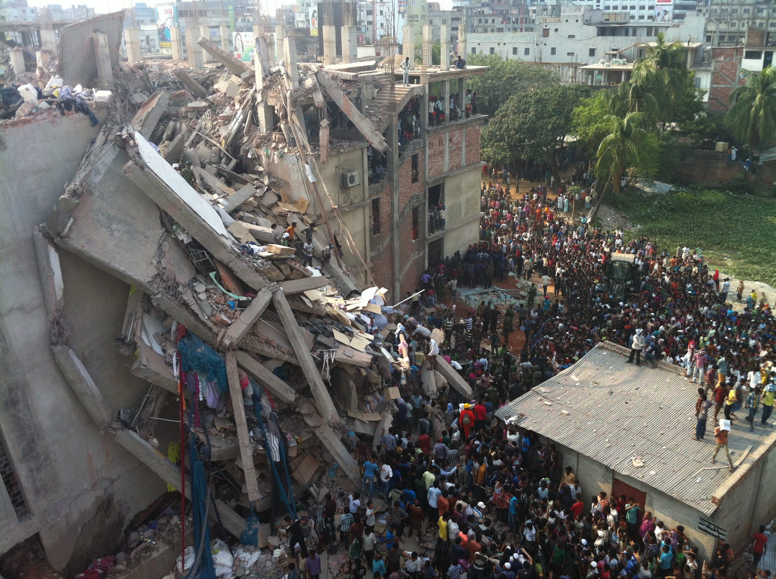
Rana Plaza after the collapse

It is thus remarkable that the country has undergone such stable economic growth, of 5-6% per year. Despite the political upheaval, which normally comes with multiple strikes and demonstrations and is still marked by corruption, bureaucracy, weak institutions etc. We all know about the garment industry – and yes, also about the disaster with the Rana Plaza building that collapsed in 2013, killing 1134 people, mostly garment workers. The RMG industry, jargon for Ready-Made Garments, accounts for over 80% of Bangladesh’s export. But also leather, pharmaceuticals and shipbuilding contribute to the ever rising economy. In fact, shipbuilding started with shipbreaking, when following a 1960 cyclone a giant cargo ship ran aground near Chittagong and local metal workers slowly began to scrounge it for scrap metal. Nowadays, shipbreaking is big business, employing large numbers of cheap, semi- and unskilled labourers, and not hampered by safety rules and environmental considerations that play a role elsewhere.


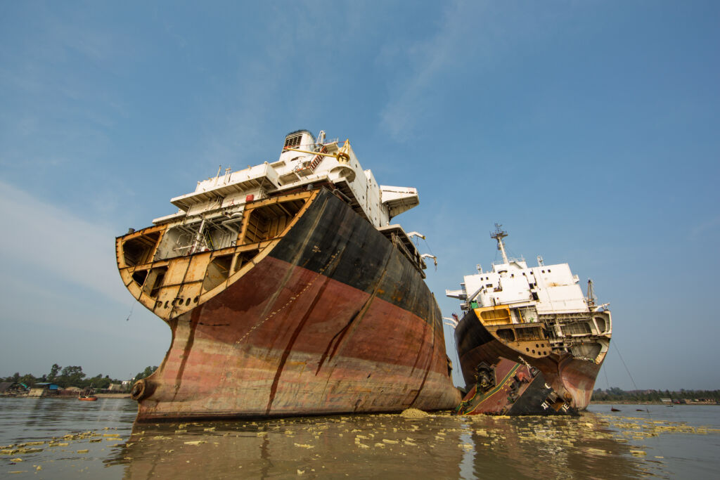
shipbreaking on the beach

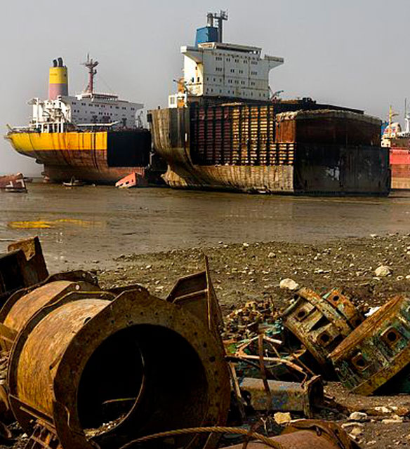
these are huge ships, taken apart over several months

Although still on the UN’s list of Least Developed Copuntries, it expects to graduate from this list by 2026, which is testimony to its success in human development, poverty reduction and significant gains in term of economic robustness. It is still a poor country, but by far not as poor anymore as I would have thought initially. I know a lot more now than when I first thought about going to Bangladesh, for the rest we will go and see for ourselves (and add my own photos to this blog, instead of generic pictures from the internet). We may be in for a surprise, who knows?

country map of Bangladesh, completely surrounded by India

Well, the truth is, I don’t know much. I know it was East Pakistan for a while, and then turned into an independent country in 1971, after a viscous war. A poor country for a long time, annually affected by massive floodings in the delta of the combined Ganges and Brahmaputra, which takes quite a lot of water from the Himalayas and the Indian subcontinent to the Gulf of Bengal. The world’s preeminent garment production centre, where young women and children are being slaved around in unsafe factories until these burn down, with horrific results: the price we pay for our cheap fashion – well, the price we don’t pay ourselves, actually, that’s why it is so cheap. Also the country that accepted well over a million Rohingya refugees fleeing genocide from Myanmar since 2017, for which it should be commended. Ruled for the last centuries by the two begums, wife/daughter of earlier dictators who increasingly adopted the policies of their husband/father, until one, Sheik Hasina, prevailed, using time-honoured techniques like putting all your opponents in jail. Until she herself had to flee the country, under pressure from demonstrating students. After which Mohamed Yunus, inventor of micro-credit and Nobel peace prize winner, was appointed interim-president in 2024.

Mohamad Yunus, inventor of micro-credit, Nobel Prize laureate and current interim president

Not surprisingly, there is more to Bangladeshi history than this. Before East Pakistan, before Bangladesh, it is the history of India, where Arab traders brought Islam in the 9th Century, culminating in the Mughal dynasties of the 16th to 18th C. And a lot more, of course, here less relevant. And then the Brits came: after an early foothold in Surat, on the West Coast of India, they established their base in Calcutta in 1690, in Bengal, which was then one of the wealthiest regions in India.

The first signs of a split up came in 1905, when viceroy George Curzon created two new provinces: Western Bengal, including Bihar and Orissa; and Eastern Bengal and Assam. With its capital at Calcutta, Western Bengal had a Hindu majority, while the province of Eastern Bengal and Assam, with its capital at Dhaka, was predominantly Muslim. Six years later, Curzon thought the better of it, and merged the two again, under pressure from Hindu forces in West Bengal, even though the Muslims in East Bengal supported the split-up.

By 1947, with the departure of the Brits, the India as it was violently split into two parts, Hindu-dominated India and Muslim-dominated Pakistan; partition was extended to Bengal, too, and East Bengal became part of Pakistan. With the only common denominator a religion, two vastly differing cultures, thousands of kilometres away.

(enter ChatGPT) From the outset, East Pakistan was politically and economically marginalized. Despite being home to the majority of Pakistan’s population, East Pakistan was underrepresented in national politics, and its economy was largely controlled by West Pakistan. One of the first major issues arose over language. In 1948, the central government of Pakistan declared Urdu the sole national language, ignoring Bengali, the language spoken by the majority in East Pakistan. This led to widespread protests, culminating in the Language Movement of 1952, during which several students were killed by police while protesting in Dhaka.

Mujibur Rahman, leader of the Awami League and first president of Bangladesh

Over the following decades, East Pakistanis grew increasingly resentful of the political and economic domination of West Pakistan. The Awami League, a political party led by Sheikh Mujibur Rahman, emerged in the 1960s as the voice of East Pakistani autonomy.

Tensions came to a head after the 1970 general elections, in which the Awami League won an overwhelming majority of seats in the national assembly, based largely on its support in East Pakistan. Despite the League’s victory, the central government, dominated by West Pakistan, was unwilling to transfer power to the Awami League. This led to mass protests in East Pakistan and demands for independence.

In March 1971, after months of political deadlock, the Pakistani military launched a brutal crackdown in Dhaka, targeting students, intellectuals, and political activists. The military operation, known as Operation Searchlight, led to widespread atrocities, including mass killings and rape. Millions of Bengalis fled to neighbouring India, sparking a refugee crisis.

On March 26, 1971, followers of the by then arrested Sheikh Mujibur Rahman declared Bangladesh’s independence. A nine-month war ensued, with the Mukti Bahini (Bengali guerrilla forces) fighting against the Pakistani military. India, which had been hosting millions of refugees, eventually intervened in December 1971, leading to the surrender of Pakistani forces and the creation of an independent Bangladesh on December 16, 1971. (exit ChatGPT)

Post-independence, Sheikh Mujibur Rahman became the country’s first prime minister, but his government faced significant challenges, including famine, corruption, and political instability. And he became increasingly autocratic. In 1975, he was assassinated in a military coup, the first of many, which brought General Ziaur Rahman (often called Zia) to power, only to be assassinated himself in 1981. In 1982, another general, Hussain Muhammad Ershad, surfaced as dictator, but was forced out by protest in 1990.

A rare 1990 photograph showing the two Bangladesh Begums, Sheikh Hasina and Khalida Zia, together, before their political polarization took off

Which, amazingly, led to something close to democratic rule, dominated by the two Begums referred to earlier: Sheikh Hasina, the daughter of Sheikh Mujibur Rahman and leader of the secular Awami League, and Begum Khaleda Zia, the widow of Ziaur Rahman and leader of the more conservative BNP. Their political battle led to intense political polarization, lots of general strikes, violent protests, and widespread instability. For a while they swapped the position of prime minister every 5 years, not hindered by accusations of corruption on both sides, and occasionally forced out by mass protests about incompetence and corruption. In the end, since 2009, Sheik Hasina proved the more astute, marginalising her competitor politically, and finally locking her, and many more opposition leaders, up, to remain in power until 2024.

When she was, in line with Bangladeshi tradition, finally forced out of power not by elections but by widespread student protests, and left last August. After which Mohamed Yunus was appointed interim-president, with the task to bring democracy back to Bangladesh after years of autocratic rule. Hmm, bringing democracy back is rather over-estimating Bangladeshi history since independence, but if anybody has credibility in this land of challenges, it is Mr Yunus.

the map of NE India, including Sikkim, surrounding Bangladesh

The visas are ready within a week. We can pick up our passports from VFS Global, no need for an appointment. This time we are outside again after ten minutes. That’s one, the Indian visa. We drive on to the Bangladeshi embassy, also in The Hague. Although technically we can only collect visa between 3 and 4 in the afternoon, we are let in, by the same friendly guy from earlier, and another five minutes later the visas have been pasted in our passports. That’s two. Within half an hour. Piece of cake.

the Bangladeshi program, criss-crossing this country in two weeks

In the meantime we have been making plans, of course. The Bangladeshi program is very much fixed by the people that organise the trip, but once we are done there, it is up to us. Without going in too much detail, we plan to cross the border into India near Agartala, capital of Tripuri state, where we are going to see some palaces and temples, and even some ancient rock carvings. This, together with the larger Assam state, is going to be the most ‘Indian’ part of the journey in the Northeast, never mind that we will also try to find our first tribal villages here.

We have been advised that Manipur is off-limits for foreigners, and even for Indians, because of political trouble – that hasn’t gone away in those 20 years we haven’t been to India. Digging a little deeper, it turns out that Kuki people, those I was earlier referring to, have actually formed armed guerilla groups that are taking on the local police and parts of the Indian defence structure, in an attempt to establish control over the border area – and thus the lucrative smuggling of drugs, arms, people, the usual business of the World’s rebel forces.

through five of the Seven Sisters, in a not so straight line

Which means that we also skip Mizoram, the southernmost state here; going here, and back, would really take too much time, also because of limited infrastructure. No trains in this part of the country, and no airports either. So, instead, we head north, into Assam state and its capital Guwahati, where we may need to spend some time in support of our permits. From here we make a brief excursion into Meghalaya, bordering Bangladesh, to connect to nature, as in jungle-like conditions, before we head into Arunachal Pradesh, the state bordering China. Here we climb to over 3000 m to explore a Buddhist monastery, after which we divert into various valleys to find further tribal villages, before getting down to the Brahmaputra river, which prominently cuts through the Northeast. Here we explore Majuli Island, the largest river island in the world, and the Kaziranga National Park, famous for its one-horned rhinoceroses.

I am trying to engage a travel agency to organise the Assam and Arunachal Pradesh part for us, but it is difficult to get them to deviate from their usual pattern. We don’t need to go wild-water rafting, and neither do we need extensive relax time, we are more from the fully packed itineraries – relaxing I can do when I am back home again!

After this part of the journey it is time for Nagaland, a state with one of the densest tribal populations in India. Which, for the time being, we are going to identify by ourselves, culminating in a tribal festival in the area of Mon and Longwa, against the Myanmar border. Well, if we are allowed in, if we indeed get our special permits, we will see. Flexibility is the key here, obviously. After this presumed spectacle, we head back to the Brahmaputra, once more, to Dibrugarh, from where we take a train to Guwahati, and on to Darjeeling. End of our exploration of five of the Seven Sisters, as these Indian states are collectively called.

and to the eight’s Sister, Sikkim, and then down to Kolkata

Only to head for the Eight’s Sister – a stepsister, if you like -, which is the old kingdom of Sikkim, sandwiched in between Nepal and Bhutan, high in the Himalayas. To admire the scenery, and more Buddhist monasteries, no doubt. And the tea plantations of Darjeeling, which is just below Sikkim. From where we take a train to Kolkata, better known by its old name Calcutta, for the last few days of our trip. We haven’t been to a real big city, yet, after all.

By then we are some nine weeks further. Exciting idea! Exciting program, too, with lots of variation.

Ah, visas. The aspect of any journey that I hate most. Not to generalize, mind you, and there are exceptions, but in quite a few embassies and consulates the attitude towards travellers is not the friendliest, not the most inviting. And if they send you to a website for online application, prepare yourself!

Right, first Bangladesh. We can get a visa on arrival, apparently, but the problem is that we intend to continue our trip overland, so we do have a airline ticket into the country, but no return ticket. And getting a bus ticket to proof we do plan to leave the country again, is complicated. So better to explain at the embassy before we take off. Hmmm. We are being referred to the website. Where we dutifully fill in the entire form, which we submit online, as instructed. We are supposed to get a response email, but after two days of not having receive anything, I decide to call, and ask what should be the next step. Application online? No Sir, we don’t do that, you need to come to the embassy in person. Am I going to argue that their website instructs otherwise? Of course not, I print out the forms, and make my way to the embassy.

Where a very friendly employee accepts our forms, our one-way ticket, our hotel reservations – the one we need, but we can cancel again as soon as we receive the visa – and our explanation why we haven’t got a return ticket. And where we pay a relatively humble amount of money only. Come back next week.

As we don’t need to leave our passports, we continue with the Indian visas. Which, luckily, has been outsourced to a company called VFS Global. Luckily, because my early contacts with the Indian Embassy were exactly as I expect those contacts to be: arrogant, non-informative, “all the answers you need are on our website”. Which isn’t the case, of course, otherwise I wouldn’t have called them in the first place.

VFS Global also works with a website, which after a bit of experimenting yields a fairly clear process, filling in various pages, and with the option to save and come back later to the same form. They need to know a lot of things, like the names of your parents, where they were born – and specifically, if you or they have any Pakistani roots. Whether you have been in the army at all. And whether you have been to India before, and when, and what was your visa number then. Yeah, 20 years ago, but how on earth do I find that visa number back? You know, just say “no”, I doubt that they were organised enough to ever find us back in the, then entirely paper-based, system. And at least they are clear that after completion, you need to print the form, and take it to their office. For which you need to make an appointment for a specific timeslot. Great, in 15 minutes in and out.

Except that once we arrive at our appointment the allocation of timeslots doesn’t work, so just get your number and wait for you turn. Which came a little more than one hour later. Knowing that the India visa is valid from the day of issuing, not from the day or arrival in the country, I had requested a three months visa. Doesn’t exist, that then becomes a one-year multiple entry visa, Sir. OK. Ahh, and you have made a mistake with your passport number on the form, there is one digit too many. Can you not correct that, cross that out? Ah, no Sir, you will have to submit a new application. Can I use the computer in the corner? Ah, no Sir, that doesn’t work anymore.

I manage a new application on my telephone, for which the website has not been designed, and after having taken several new passport photographs – the ones we brought weren’t good enough – my application was finally accepted. By, admittedly, very friendly and helpful staff, except that they must follow the rules. But no need for flight details, no need for hotel bookings. “Please, you can follow online when the visas have been processed”. One week.

Perhaps.

Or so I thought, when I started to put the India part of the trip together at the end of 2024. Only to learn that, on December, 20 of that year, the Indian government decided to reintroduce the permits again for the states bordering Myanmar. Mizoram, Manipur and Nagaland (Arunachal Pradesh always needs a permit, but is now an established process, so relatively easy). Hmmm. Enthusiasm was ebbing away, again. These happen to be the most interesting states, with plenty of minority tribes with their own ways of living, their own colourful attire, their own religions, their own festivals.

Of course, many websites haven’t registered this change of policy yet, and nobody has yet identified how to arrange the necessary permits, where to apply, how to apply. When in doubt, call the Indian Embassy. Who couldn’t do more than refer me to their website, where all the relevant information can be found. Which is not the case, of course not.

I decided to call a good friend of mine, who is Indian, and lives in India. In fact, we were planning to visit her on the way back from Bangladesh, on the way back from the Northeast. And as things go in India, she knew somebody else, and I don’t have to worry anymore, all will be arranged. “Just send me a copy of your visa, and I’ll take care of the permits”.

no, this is not a Kuki woman, but a tribal woman from Orissa, from an earlier encounter in India, 20 years ago – but it goes to show!

We never even considered going to Bangladesh, what on earth would we be doing there? But opportunist as always, when I received this email announcing a two week trip to Bangladesh, from the same organisation that arranged the highly successful trip to Syria last year, I asked my customary travel partner – on a cold and miserable day in December – what she thought about it. And she said: “why not?”. The itinerary includes some quirky exclaves from Bangladesh inside India, Buddhist temple ruins, a couple of mosques, palaces from the colonial era, a river cruise or two, including to the Sundarbans – the largest mangrove forest in the world, and a Rohingya refugee camp. We finish with the ghost city of Panam and an exploration of the capital, Dhaka. Enough to keep us entertained for two weeks, and – the best of it – utterly not touristic. Or so I imagine.

not sure what the ‘standoff’ is all about, but I found this on the internet, showing the Seven Sisters and the Chicken’s Neck, all of it kind of surrounding Bangladesh

Kukiland, the area where Kuki tribes are living – which includes a part of Myanmar, and also Bangladesh

Well, we finish in Bangladesh, but then it occurred to me that the shortest route out is to the Indian state of Tripura, one of the so-called Seven Sisters – no, not the oil companies, but the seven states of Northeast India. That part of India located between Bangladesh, Bhutan, China and Myanmar. Only connected through what is called the “chicken’s neck” – the 22 km wide Siliguri Corridor squeezed in between Bangladesh and Nepal – with India proper, so to speak. This is Kuki-land! Well, not many people use this term these days, but it refers to some of the dominant hill tribes in the area, which belong to the Kuki-Zo (the Kuki people). They live in almost all of the seven states in NE India, together with other tribal people, to be sure. And lots of other Indians, no doubt. But tribal people, with their own culture, customs, religion, that is interesting, of course!

We have long wanted to visit the Northeast, beginning with when we lived in India 20 years ago, but never managed. At the time, because foreigners needed all kind of difficult-to-obtain permits, on account of continuing unrest in many of those states, from independence movements, as well as border sensitivities, especially with China and Myanmar. And afterwards, because we actually never got close, and it drifted off the radar somewhat.

But being already in Bangladesh, what could be easier than hopping across to Tripura, and from there on to further India states with exciting names as Mizoram, Manipur, Nagaland and Meghalaya. In fact the biggest states here are Assam – easy, no permits needed – and Arunachal Pradesh – complicated because of unresolved border disputes with China. All, except for Arunachal Pradesh, easily accessible today, no permits needed, focus is on stimulating tourism.

decoration on the tomb of Ottoman governors, proud heritage in Travnik

In sharp contrast to Zenica, Travnik is a rather low-key, low-rise town, a little left behind. During the Ottoman occupation of Bosnia it figured for a while, 18th and 19th C, as the local capital of the Ottoman Bosnia province, which not only prompted many locals to convert to Islam, but also sparked the construction of quite a few mosques. The most outstanding example of this is perhaps the most beautiful mosque in the country, the Suleimanyi Mosque, popularly known as the multi-coloured mosque. Which, indeed, is quite a structure, and quite nicely decorated, outside as well as inside – it was open! Travnik is still a Muslim stronghold, and the residents seem to be proud of their Ottoman heritage. Many of the Ottoman viziers – governors – of that time have their tombs still in the city.

one of the tombs of the Ottoman viziers

elaborately carved tombstone

and a decorated pillar of the tomb

one of the tombs at night

the front of the Suleimanyi mosque, or multi-coloured mosque

and some of the arches at the side of the mosque

the colourful fountain, at the back

and one of the windows, equally colourful

the colourful mosque from the inside

part of the ceiling, and wooden pillars, decorated

the mihrab, inside

another view of the mosque, all of it

the twelve sculptures of the Necropolis for the Victims of Fascism

The Spomenik

There is a fortress and an old town in Travnik, which we left unexplored. Instead, we made our way to Novi Travnik, to see the Necropolis for the Victims of Fascism, a spomenik – a Socialist monument from the former Yugoslavia – created in 1975 on a hill outside town. Twelve stones with abstract faces, all almost the same, on both sides, commemorate some 700 civilians who died at this site in a brutal massacre committed by occupying Croatian Ustaše forces in August 1941. (https://www.spomenikdatabase.org/novi-travnik)

strange figures, and strangly attractive

from another angle

in another use of concrete, to be sure

on the way, once more spectacular autumn landscape

and we are not the only one enjoying it

the Maculje necropolis, a collection of stecci

The Stecci

Half-an-hour further is another necropolis, called Maculje, a collection of stecci similar to the ones we saw in Montenegro earlier. The stecci – 12th to 16th C tombstones – are in fact not very interesting. They are aligned in rows N-S and E-W, mostly, but many are barely recognisable as a tombstone, and there is nothing of the decorations and carvings of the Montenegrin sites. However, on the outer boundary of the site here are a series of upright stones in the form of a cross, and these do have carvings, quite explicit even. I cannot work out whether the crosses are associated and time-equivalent with the stecci, but they are a nice addition.

and others decorated with crosses

which are 12th to 16th C tombstones

some in the form of tombs

on the way to Travnik we visited the small, strategic fortress in Vranduk

the small tower of the fortress

and the courtyard, just to show how small the fortress really is

The Road to Mostar

From here we drive on to Mostar, the long way around, close to the Croatian border, because the centre of Bosnia and Hercegovina has been hit by massive floods; agencies are working around the clock to try to find missing people, to clear the mudflows, clean up the debris of destroyed houses; roads are closed. For us it means just an extra half-an-hour drive, or so, first through the beautiful mountain landscape, with exploding autumn colours – lovelier here, across rolling hills, but less dramatic than those in Montenegro. But it also allowed us to observe the Croatian part of Bosnia, once one of the three fighting parties during the war, together with the Bosnian Serbs and the Bosniaks, the Muslim population – all engaged in ethnic cleansing, to be sure. The first thing that we notice is the frequent Croatian flags, or other obvious expressions of Croatian – not Bosnian – nationality. We also note, in several areas, houses shot up and abandoned: walls with holes, roofs collapsed. I suppose these were once owned by Bosnian Serbs – who dominated this area before the war, but have been pushed out, further north. And the houses that are inhabited, are mostly new, or well patched-up. Oh, and there was obviously also some spare cash available to build new churches, Catholic churches, and they are huge, just to make a point, I guess.

Notwithstanding all this demonstration of who is in charge, here, we are also driving through what looks to be the most prosperous zone of Bosnia and Hercegovina. There is agriculture, sheep and cattle, but also a lot of business enterprise. Not just construction, as we saw in Kosovo, for instance, but a wide range of modern companies contributing to the local economy. Quite different from what we have seen in the past few days, in the Serb and the Muslim part of this country. Quite different from the rusty factories in Zenica, for instance.

colourful trees as far as the eye can see

fire escape of the Internacional Hotel, Brutalist example in Zenica

We didn’t plan to go to Zenica at all. After all, what on earth is there to see? But through our newly developed interest in brutalism, or socialist modernism, suddenly a couple of ideas had popped up, mostly centered around hotels. Some specialist website mentioned the Hotel Internacional, and the Hotel Dubrovnik, both in Zenica. And anyhow, it was more or less on the way.

the Lamela building, with its curious step-up construction from low-rise to 25 floors

again, the Lamela building, with focus on the high-rise

and some stairs leading out of the first floor of the building

But driving into town every thought of hotels is quickly overshadowed by a huge apartment building, the Lamela building, a residential tower 25 floors and 101 meters high. According to one of the local residents we get to talk to, it was built in 1975, and at its time it was the tallest building in the Balkans. And it is a fabulous example of Brutalist architecture, as far as I am concerned.

this is the Internacional Hotel, closed and fenced off

the concrete, Brutalist credentials of the Dubrovnik Hotel are obvious, even after refurbishment

the concrete here is equally, if not more obvious

with an impressive, once again concrete, entrance

and more concrete construction details

The Hotels

In fact, Lamela is literally overshadowing the hotels, Dubrovnik on one side – now neatly refurbished and looking like a flash hotel, and therefore not that interesting anymore for those truly focussed on Brutalism -, and Internacional a little further on the other side. The latter one is, indeed, a gem, all you want from social modernism, lots of concrete, strange angles, the inevitable fire escape, and slowly rotting away. Apparently, the hotel folded not so long ago, and maybe auctioned off in the future, to attempt a new start in private hands. I hope so, it is worth it!

one curious apartment building, refurbished on the right but in original state on the left

Brutalist is not confined to the centre of town, these are apartments on the outskirts

and this, too, is a fabulous example of Brutalism

And then it turns out that Zenica has a lot more to offer, in terms of socialist architecture. The town was rapidly developed after the war, and its population grew from 15,000 in 1948 to 30, 000 in 1961 to 60,000 in 1981. To accommodate all these people construction of apartment buildings – many a bit higher than the standard pallatis – was booming. Everywhere you look are residential high-rises, one even more extravagant than the other.

The Factories

It is only when we drive out of town that we realise why. This is the industrial heartland of Bosnia and Hercegovina, with factories bulging out their smoke, as well as iron- and metalworks, apparently. Manufacturing plants as far as the eye can see. Which, at least at that time, needed workers, of course.

No regrets stopping off in Zenica!

outside town, the factories, great examples of communist rust buckets

and a couple of cylinders which can be climbed, too

rust being the dominant colour here, too

lots of metal construction, walkways and stairs

the Igman Hotel, Brutalist hotel for the 1984 Olympics in Sarajevo

Well, the absolutely very best of Brutalist Sarajevo architecture, then, for the very last. Outside Sarajevo is another hotel, built for the Olympics. The 162-room Igman Hotel, close to the past ski jumping station, did not survive the war, and has been abandoned since. They don’t come much more Brutalist than this, one hump of solid concrete, yet artistically distributed, apparently representing traditional Bosnian forms. As with abandoned places, they are a great place for graffiti, mostly of the more constructive kind; wandering through the hotel and up its five or six floors is a great experience – at least for those with a recently developed interest in Brutalist architecture.

the main entrance of the hotel

what used to be the pool, I suppose

another view of the hotel

and one more, with autumn colours

it cannot get more concrete than this

the only colour provided are autumn colours

concrete and trees

not much left inside

although the stairs still operate

the other colours come from graffiti

not fabulous, but everything counts, in such a drab location

once more, now the whole picture

the nearby ski piste

in its full glory

balconies in the Alipasino Polje neighbourhood of Sarajevo, the laundry providing some colour amidst the concrete

I am fully aware that not everybody is equally fascinated by our latest discovery, Brutalism. Which is why I will not flood the – already pretty flooded – main entry on Sarajevo with too many photos of apartment buildings from the communist era, when lots of accommodation was called for at low cost, yet still fitting the ideology.

the housing towers, with large patches of park green in between

The Alipasino Polje neighbourhood was built in the 1970s. It not only is home to some 27,000 people, but also shops and schools and playgrounds, the things that make a community, not just a housing estate. Whether this approach has been very successful is questionable, as it may have turned into a magnet for the unemployed and a hotbed of crime and drugs abuse. Not that we saw anything of that on our walk through the various sections, creatively called Faza A, B and C. Whatever, it is fascinating architecture, if you ask me.

the reality of Alipasino Polje

in close up it doesn’t look a lot jollier

different types of housing towers

differing in colour, at least

another of the designs

better viewed from a distance

attempts at some form of decoration

community facilities, like a school

and even a videoteka! – admittedly, closed by now

once more, a little colour from the laundry – very little

if you zoom in, you can get away from most of the concrete

some buildings have names, even

and this one comes from the internet, an overview of this jolly neighbourhood