
the mountainous countryside in which the Indians and the Chinese fought their senseless war in 1962
I am not going to analyse the Sino-Indian war of 1962 in great detail. In short, parts of the border between China and India have been, are still being disputed, and an important part of the dispute is the border in Arunachal Pradesh. In this area, in particular, the Chinese maintain that Tibet had no right to cede territory, including the area around Tawang, to the British at the 1914 Simla Convention; British India later turning into present day, independent India.
The legal claims to what is, or is not, the correct border go back to the 19th Century, when various Britishers declared a certain borderline, often ambiguous, without properly agreeing this with other nations, aka the Chinese. Later negotiations between independent India and Communist China did not resolve the issue either, which led to the Chinese invading India, in the west and in Arunachal, at the end of October 1962 – why you would do this in the winter, at altitudes well over 3000 m, beats me, but I am no military tactician.

one of the big army bases along the road to the Sela Pass
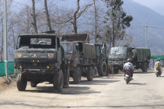
army trucks are a frequent sight on the roads, too
The War
And indeed, most sources concede that most of the war victims succumbed to the cold, not to enemy fire. In any case, casualty numbers, disputed by both sides, ran in the thousands, whereby the Indians lost probably three times as many people as the Chinese did. In the so-called Eastern Theatre, Arunachal Pradesh (then called North East Frontier Agency), the Chinese mostly overran the Indian positions, and conquered their intended territory in three days. Tawang was evacuated by the Indians without resistance; they withdraw to the Sela Pass. After a few weeks of negotiations, which then broke down again, the Chinese attacked once more, extending their occupation to close to the Brahmaputra river. Two days later, on 19 November, having conquered much more than their original territorial claims, the Chinese declared a unilateral cease fire. And from December 1st, they withdrew again behind the pre-war border. Why so many people had to die, it beats me (although the quicker than expected resolution of the Cuban missile crisis, and the subsequent deployment of an American aircraft carrier to the region may have had something to do with it, according to historians).

another army camp, from above
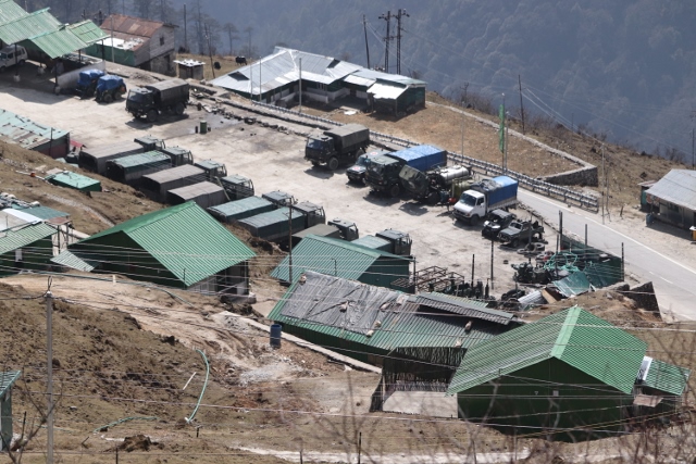
including another range of trucks

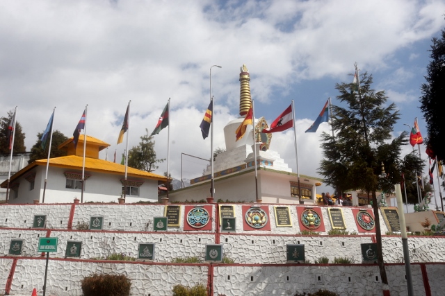
prayer flags at the the Nyukmadung Monument, maintained by one of India Army’s fearsome divisions

the entry to the Nyukmadung Monument itself

and if you read this carfeully, you unerstand that Indian forces were routed, no less – click on the picture to enlarge

the Memorial for Jaswant Singh Rawat, once again maintained by the Blazaing Swords – if you wouldn’t know better, it could be the name of an American sports team

the small memorial building itself
The Memorials
On the Indian side, the war is still being remembered. On the way to the Sela Pass we stopped at one of those monuments, the Nyukmadung Monument, named after the battle here on 17 November 1962. Even the heroic text describing the Indian bravery cannot disguise that the Indians were completely outmanoeuvred and overrun. And subsequently, just after the Sela tunnel, we stopped at another, the Jaswant Gargh Memorial. Jaswant Singh Rawat was a rifleman who single-handedly kept the Sela Pass from advancing Chinese troops for 72 hours, starting 17 November (except that most of the Chinese army bypassed the pass, and reached Tezpur at the Brahmaputra after 48 hours). Jaswant was helped by to two local girls, Sela – after who later the pass was named – and Nura – who was later remembered in the Nuranang Falls. What is nice, is that this memorial also provides room for the Chinese victims, many of whom have been buried here.
and this is the Tawang War Memorial

with the names of fallen soldiers and officers in black marble
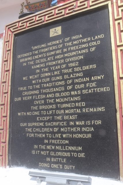
as well as this boostful, yet doubtful text, especially the last sentence – click on the picture to enlarge
In Tawang is the Tawang War Memorial, in the form of a Buddhist stupa, and several rooms with war maps. Outside, the victims on the Indian side – 2420, who died in the Kameng district – are being listed on black stones, by regiment. I know every military honours its fallen comrades in a similar way, but I just have difficulty with phrases like “we went down with guns blazing…crushing thousands of our foes…” Or this one: “is it not glorious to die in battle doing one’s duty?”. It is not.
That the area is still military very sensitive is visible all over. We encounter multiple military bases along the way, on both sides of the Sela Pass, and there is a lot of military traffic on the roads, as well. Interestingly, they don’t seem to mind their facilities being photographed. I suppose the good thing is that they keep the roads open. The Border Road Organisation, BRO, is part of the army.
next: to the Sela Pass itself

the BRO, or Border Roads Organisation, at least does very useful work by maintianing the roads – including opening the passes again after heavy snowfall
