
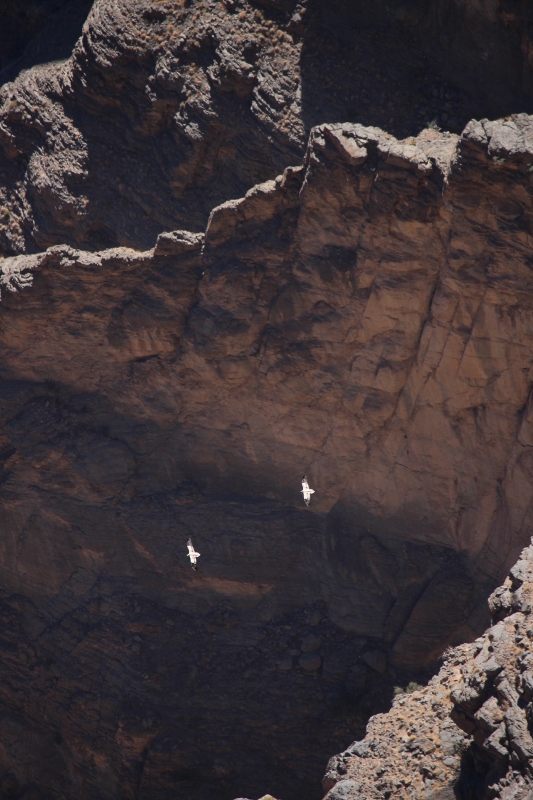
looking down into Oman’s Grand Canyon
The prospect of living in Oman for a while is a very real one for a Shell employee, but somehow I never managed whilst working for the oil company – or perhaps I didn’t work long enough for them. So we fitted in a two week trip early in 2017, to this increasingly popular tourist destination: two weeks is by far not enough, of course, but it does allow us to gain an impression of what there is to see and how this country works.
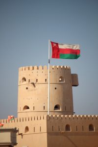
one of the many Omani forts
Introduction: Oman is working hard to promote tourism, as one of the few countries in the region; this could well be a funcion of its outward looking past.
The Arabian peninsula has never been the easiest tourist destination in the world. Apart from the practical difficulties of getting in – the largest country, Saudi Arabia, being off-limits for most casual travellers because they don’t issue tourist visa, and the most attractive one, Yemen, is mired in a civil war -, there is actually the very real question of what to do, in Arabia. Dubai and Abu Dhabi are developing into major shopping hubs, but outside these modern artificial oilmoney-fuelled urban mini-states, there is only the desert, right?
Well, not entirely. There is also Oman…. read more
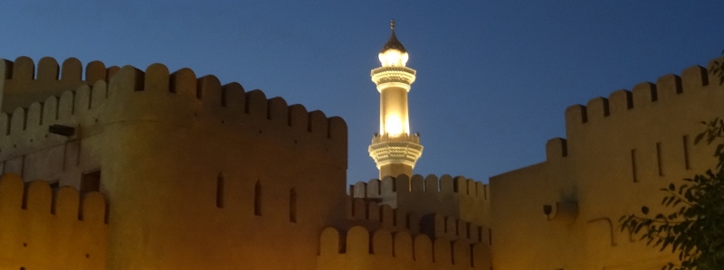
Muscat
Muscat: Oman’s capital Muscat is a pretty humble city, a series of characteristic coastal villages
For those familiar with the capital cities on the Arabian Peninsula, Muscat is a humble place. Arrival is at the relatively down-to-earth airport, nothing compared to the flashy neighbours (but rumour has it that this will change soon, too, and evidence of a new terminal building is there). And elsewhere in town, too, no high-rise, no ostentatious expressions of oil wealth; no senseless competition to build the highest tower or the most luxurious artificial island. Humble is the word that fits Muscat.

the wadis
The Wadis: A trip to Wadi Beni Kharous and Wadi Beni Awf, with a stop at the impressive, but heavily restored Nakhl Fort on the way
A popular outing from Muscat is a day trip to the wadis west of the city. A wadi is a river bed in arid areas, which means that for most of the year it is dry, and thus easily accessible. Make no mistake, though: if it rains, or if it rains upstream, the wadis are subject to violent flash floods, exactly those moments you don’t want to be trapped there.
There are several wadis coming down from the Western Hajar Mountains, the nearest to Muscat being Wadi Beni Kharous and Wadi Beni Auf. On the way, there is Nakhl, a small town with a big fort. We are certainly not going to see all forts in Oman – there is an estimated more than a 1000 fortified structures in the country -, but the Nakhl Fort, apparently, is one of the best.
Nizwa
Nizwa: Oman’s interior is ruled from Nizwa, which offers not much except for good food, and is an excellent base for exploring the surrounding mountains and forts.
From Muscat it is a couple of hours drive to Nizwa, the main town in the interior of the country, on the other side of the Hajar Mountains. The modern highway passes through the Sumail Gap, a natural break in the mountains and the most obvious route inland. Because of this, the area is plastered with forts and watch towers wherever you look, remnants of the old defence works for this most strategic of passes.

Bahla Fort
Bahla and Jabreen: Outside Nizwa are the towns of Tanuf, Bahla, Jabreen and Fiqain, each with their own story, often expressed in the state of their buildings.
Tanuf, half an hour outside Nizwa, looks, on the face of it, a modern town. However, towards the back of the town, almost against the mountain slope, are the derelict quarters of an older version. In the 1950s plenty of Omanis were dissatisfied with the Sultan, the father of the present one, and a group of rebels led by an elected Iman, and covertly supported by Saudi Arabia, tries to overthrow the regime. They hid in the mountains – the jebels, in local language -, which explains the term Jebel War, in which equally covert British troops supported the Sultan. And Tanuf was made an example, when it was deliberately bombed on 27 July 1957.

Jebel Shams
Jebel Shams and Jebel Akhdar: From Oman’s mountains Jebel Akhdar and Jebel Shams are easiest accessed, both providing spectacular views
Nizwa is a good base for excursions into the Hajar Mountains, the mountains that separate the interior of Oman from the coast. Nearest is the road that leads up to Jebel al Akhdar, which starts at the village of Birkat Al Mawz, some 45 minutes out of Nizwa, in the direction of Muscat.
Just past the village is a police check point, assessing whether you have a 4WD or not – without it, no access to the mountain is granted;
Misfat
Misfat and Al Hamra: Several villages, amongst them Misfat and Al Hamra, are perched against the Hajar Mountains, in between Jebel Shams and Nizwa.
On the way down from the mountain we turned to Misfat village (fully Misfat al Abriyyin, to distinguish it from other Misfats), one of those mountain villages built on a steep slope, and somewhat reminiscent of Iranian villages. As is often the case, the view of the village is best from the other side of the valley, from where one also gets a good impression of the extensive plantations that surround the place, well irrigated, and full of date palms and bananas. Inside the village, once again lots of dilapidated houses, fringing the narrow alleys and passage ways.
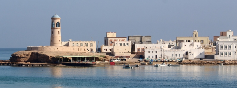
Sur
The Sharqiyah: the eastern-most province of Oman, where the old trading towns Ibra and Sur are located.
This is rapidly becoming a tale about, for one reason or another, deserted villages and towns. Whether civil war-bombed Tanuf, crumbling Fiqain or abandoned Al Hamra, in many places we encounter houses that have been left by their occupants.
Ibra is another case in point. Located in the eastern Hajar Mountains, in the province of Sharqiyah, this was an important town in colonial times – Oman as a colonial power, that is. It controlled the trade with Zanzibar and along the East African coast -, which can be seen from the homes of wealthy merchants, who traded. The houses have now been abandoned and are falling in disrepair.

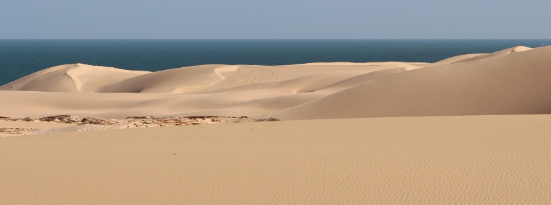
coastal road from Sur to Salalah
Sur to Salalah, the Coastal Road: The first half of the Coastal Road from Sur to Salalah passes through Mahout, the extensive dune fields of the Wahiba Sands, and Ad Duqm, the mother of all infrastructure projects. A bad storm limited not only our visibility, but also our options.
The quickest road to Salalah, from Muscat or Nizwa, and even from Sur, is the road that cuts through the centre of Oman, part-dual carriage way, part-four lane, but for almost its entire length completely uneventful. Look left or right, it is flat desert landscape. However, there is also a coastal road: much more attractive, albeit somewhat slower. So that’s a no-brainer.
the coastal road, continued
Sur to Salalah, the Coastal Road continued: The Coastal Road from Ad Duqm to Salalah passes through much less inhabited country, safe the occasional fishing village and camel herd.
Having rested in a comfortable environment, and fed on several buffets, we continued our journey the next day. The wind was marginally less ferocious than the day before: our car was not being sand-blasted anymore, but everywhere was still a lot of dust in the air, and where sand was available, it blew across the road, dramatically reducing visibility. For much of the journey, there was no sand available, we crossed a desolate, empty gravel plain. One of those areas where you wouldn’t expect anything. Wrong. Even here the occasional camel would be nibbling on the sparse vegetation of low, flat acacia-type trees.

Salalah
Salalah: An entirely different region, and atmosphere, is Dohfar and its capital city Salalah, ancient home of the francincense trade.
Salalah, capital of the Dhofar region in the far south, is the second largest town in Oman, and it shows. It is a modern city, once again with huge roads and plentiful round-abouts – including grass along the sides, something we haven’t seen for a while. Buildings, too, are mostly modern, and like Muscat not excessively tall, 6-7 storeys high at max. The town centre is full of restaurants, ….


