Alfredo Hlito (Arg) - Effigy in relative balance (1991), 150x100 cm

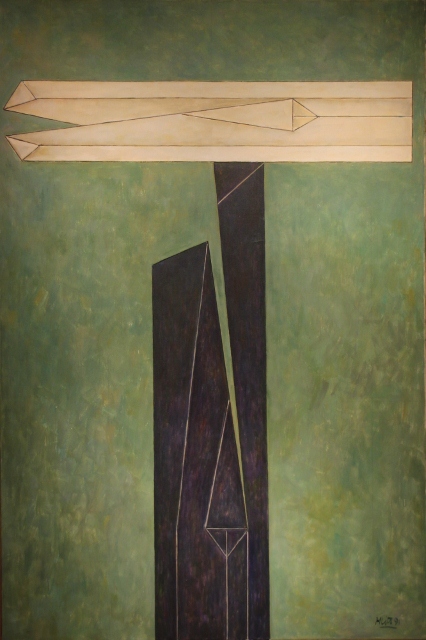
Alfredo Hlito (Arg) – Effigy in relative balance (1991), 150×100 cm

Excellent collection of modern art from Latin America

One of the newer museums in Buenos Aires is the MALBA (Museo de Arte Latinoamericano de Buenos Aires), established in 2001. The museum has a really nice collection of modern Latin American art works, a category that is often under-represented in museums across the world. A variety of paintings and sculptures from the 20th Century show that quite a few South Americans could compete quite well with their more famous colleagues in Europe. Mexicans Diego Rivera and Frida Kahlo and Cuban Wilfredo Lam are perhaps the best known artists represented in the MALBA, but the works of a host of in Europe lesser-known Argentinean, Brazilian and Uruguayan artists are also well worth a visit to this museum.

A small sample of the collection, in pictures – nothing compared to the real thing, of course.

Juan Carlos Distefano (Arg) - In diagonal II (1986), 108x70x103 cm

Juan Carlos Distefano (Arg) – In diagonal II (1986), 108x70x103 cm

Antonio Berni (Arg) - the open door (1932), 55x45 cm

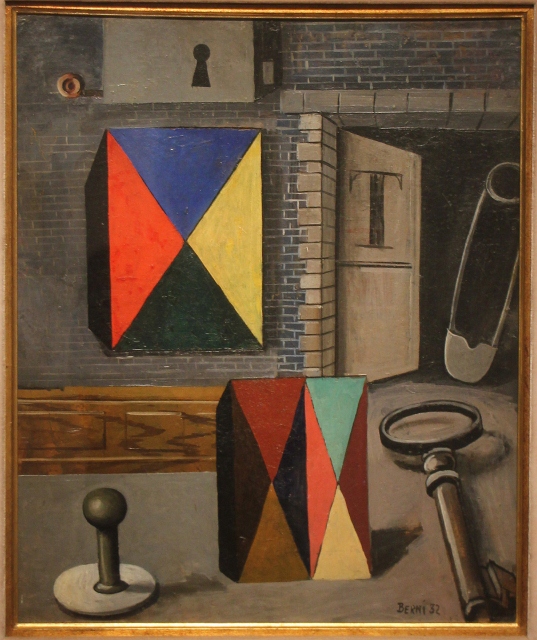
Antonio Berni (Arg) – the open door (1932), 55×45 cm

Diego Rivera (Mex) - Portrait of Ramon Gomez (1915), 110,5x90,5 cm

Diego Rivera (Mex) – Portrait of Ramon Gomez (1915), 110,5×90,5 cm

Pedro Figari (Uru) - candombe (1921), 79,5x88 cm

Pedro Figari (Uru) – candombe (1921), 79,5×88 cm

Tarsila do Amaral (Bra) - abaporu (1928), 85x73 cm

Tarsila do Amaral (Bra) – abaporu (1928), 85×73 cm

Emilio Pettoruti (Arg) - la cancion del pueblo (1927), 74x65 cm

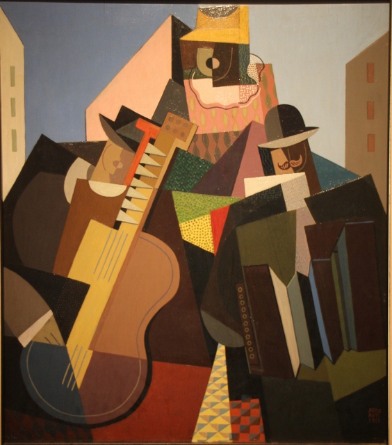
Emilio Pettoruti (Arg) – la cancion del pueblo (1927), 74×65 cm

Pablo Suarez (Arg) - Exclusion (1999), 189x199,5x32,5 cm

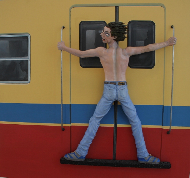
Pablo Suarez (Arg) – Exclusion (1999), 189×199,5×32,5 cm

Berhale girl

Berhale girl

Pleasant village at the edge of the Rift Valley Escarpment of the Danakil Depression.

Berhale is a village at the edge of the Danakil Depression, kind of half-way climbing up the Rift Valley Escarpment. One passes here on the way to or from Hamad Ele and the Dallol sulphur springs. The village is also a stop-over for the camel caravans that bring salt from Lake Asale to the markets of Mekele, high on the plateau outside the Danakil Depression. There is no reason to stay in Berhale, especially with improvements to the road into the Danakil, but it is a pleasant-enough place for a brief stop, and for a stroll around.


dramatic landscape at the edge of the Danakil Depression

dramatic landscape at the edge of the Danakil Depression

Berhale village, and resting camels

Berhale village, and resting camels

Afar woman

Afar woman

Berhale man

Berhale man

camel caravan climbing down the escarpment

camel caravan climbing down the escarpment


colourful deposits in Dallol

colourful deposits in Dallol

Technicolor spectacle of sulphur springs and pools in an otherwise grey desert environment.

Nothing prepares you for the sulphur springs of Dallol.

salt erosion on the slopes of Dallol

salt erosion on the slopes of Dallol

For several days we have traveled through the Danakil Depression, an area without colour (or it must be the glowing lava of the Erta Ela volcano at night). Everything here is bleak, black, grey, sandy coloured.

further erosion patterns in the salt

further erosion patterns in the salt

The huts we have seen are light brown, blending in well, and in any case, the little colour that may have existed has long ago been covered in dust, from passing cars, or from the ferocious wind that all too often blows across the desert.

Not so in Dallol. After having crossed the totally flat, dry salt lake, one reaches the hills, which turn out to be mostly brownish and grayish salt, eroded in the most bizarre forms. But once you come to the top of the slope, the other side turns out to be a screaming explosion of colour, a landscape of sulphur springs, white mounds, yellow, orange and reddish deposits, with small blue and green ponds in between. Astonishing, really, one cannot imagine a bigger contrast.

view of the sulphur springs, just across the hill

view of the sulphur springs, just across the hill

and another view

and another view

Walking around here, initially a little uneasy, on the darker parts of the surface, which somehow seem stronger, is a whole new experience. Everywhere are little, sometimes larger, fountains splashing hot water; when we come closer we can hear the water boiling underneath the surface; steam is coming off the more violent springs. Many of the vents that have formed on the surface have a white cone of fibrous sulphur around them. It is almost a crime to walk here, and to destroy this delicate process of creation. I could spend the whole day here, in awe – but it is actually pretty hot from the combined forces of earth and sun.

salt worker

salt worker

A small village entirely depending on salt winning from the lake, and transport of the salt slabs.

There are no roads from Dodom to Hamed Ela, the village near the salt works of Lake Asale, and also the base for a visit to the Dallol sulphur springs. With imagination, one recognizes the occasional track, but more often it seems to be just the gut feeling of our road runner, a local Afar who claims to know the way. Small trees are flattened in the process, occasionally a hamlet is covered in the cloud of dust we produce. We get stuck in the sand a few times, we get to a salty spring where hundreds of camels are drinking. And we hit something of a real road again. Miraculously, we have indeed found our next destination, Hamed Ela. Quite an achievement, given the size of Hamed Ela!

salt workers near the Lake Asale

salt workers near the Lake Asale

salt blocks being collected and packed onto camel and donkey backs

salt blocks being collected and packed onto camel and donkey backs

activity at the salt winning place

activity at the salt winning place

camels resting ahead of their two-day journey to the salt markets

camels resting ahead of their two-day journey to the salt markets

The people of the village earn their living from salt. The village and its 4000 inhabitants or so live at the edge of a huge salt lake, Lake Asale, which for most of its expanse is dry – it is hard to believe that this area is covered in water during the rainy season. Miners cut the surface, extract huge slabs of salt, and then cut and shave them to a standard size that can be transported on camels and donkeys to the market at Berhale, two days trekking away (traveling by night only, during the day it is simply too hot to move), and further on in Mekele. Each late afternoon, enormous camel caravans move from the lake, via Hamed Ela. And a few days later the caravans return, empty. But the miners stay, day in day out, spending the whole day under the burning hot sun, on a burning hot white salt plane. And it is not that salt is a rare and expensive commodity, here.

salt mountains on the sides of an ephemeral stream

salt mountains on the sides of an ephemeral stream

more salt mountains

more salt mountains

and this is how it looks in detail

and this is how it looks in detail


A little further north salt occurs in yet another form, as enormous salt mountains in which over millions of years steep valleys have been cut by rain water. In detail, many of the salt surfaces have eroded further, and sharp spines have been formed along them. A phenomenal natural feature.


salt caravan passing through Hamad Ele

salt caravan passing through Hamad Ele

the caravan also includes donkeys

the caravan also includes donkeys

man in Hamad Ele

man in Hamad Ele

accommodation in Hamad Ele

accommodation in Hamad Ele

the Erta Ale crater wall, hot lava sticking on the inside

the Erta Ale crater wall, hot lava sticking on the inside

Spectacular night visit to a lava-spewing volcano

Ascending the Erta Ale volcano is normally done starting early evening, when it is a little – only a little – cooler. It is getting dark quickly, and soon we walk by torch light, carefully avoiding sharp edges and holes in the surface. Separately, a camel takes up our camping gear and some food and water.

the Eta Ale crater, at night

the Eta Ale crater, at night

Still some two hours away, we start seeing the glare from the volcano, and when we come closer, we see the steam, we smell the sulphur. After having caught our breath after the 3.5 hour ascend, and after we have established ourselves in one of the huts at the top, where we will spend the night, we climb down the crater rim. Erta Ale has two craters, one inside the other, and the surface of the outer one is made up of fibrous, once again undulating, lava. Sometimes the rock crushes under our shoes, collapses, making us drop a little. Never more than 10-20 cm, but it is an eerie feeling, especially because it is pretty dark everywhere. Getting closer to the rim of the inner caldera, we start feeling the heat. Below – perhaps 50 to 100 meters down, difficult to estimate -, the floor of the inner caldera is entirely liquid; although parts of the lava lake seem dark, we can see the surface moving in angry waves, as if a bad storm blows over the lake. Some cracks in the dark surface allow a view of what is going on below the surface, and in case your imagination is insufficient, from time to time fountains of yellow and red-hot lava splash up along the rim, the glowing fluid clearly sticking to the rock afterwards.

an explosion illuminates the crater floor

an explosion illuminates the crater floor

another explosion

another explosion

the rim and the floor of the outer crater

the rim and the floor of the outer crater

the crater at daytime, looking much smaller

the crater at daytime, looking much smaller

Of course I need to see this in daylight too, so where most other tourists descent at dawn, to avoid the heat of the day, I have to get back into the outer crater, at first light. The softish rock we were walking on last night is silvery coloured, and once again, solidified in beautiful patterns.  And wherever there is a strong sulphur smell – much stronger now than earlier, and almost suffocating in some areas – yellow threads, fibres, are attached to the rock.

porter carrying stuff down

porter carrying stuff down

The crater is as active as the night before, and as impressive, although in daylight it is actually much smaller than we had anticipated. The contrasting glows are less pronounced, but you still get a pretty good idea of what is going on, down there.

irregular surface of solidified lava on the crater slope

irregular surface of solidified lava on the crater slope

some plant life still exists in between the rocks

some plant life still exists in between the rocks

the slopes of Erta Ale

the slopes of Erta Ale

sunrise over the crater

sunrise over the crater

When we walk down the mountain, the next morning, we actually see the slopes of the volcano close-up. Lava flows have come cascading down the outside solidifying whilst the inside was still fluid, creating what is known as pahoehoe lavas, with undulating, wavy surfaces. Fabulous structures. It is just a pain to walk on, even in daylight.


NB: Pahoehoe lava comes from an Hawaiian word and describes the ropy, undulating structure, which results from the outer surface of the lava flow cooling first, whilst the inner parts remain more viscous for a longer period. Common in Hawai, obviously.

solidified lava stream

solidified lava stream

Another village, spring board for visiting the Erta Ale volcano, in some of the most desolate landscape you’ll ever see.

The way to Erta Ale leads first to the village of Dodom, once again a real village in the middle of nowhere. Dodom even has a school, and other brick buildings, not everything is corrugated iron like the few other villages we have come through in the Danakil Depression. Outside Dodom, stone structures that are likely to be graves.

But the area around the village is some of the most desolate landscape I have seen, yet attractive in its uniqueness. Black stacks of basalt, and what can be recognized as lava streams – solidified black stone not unlike asphalt – as far as the eye can see. You can just imagine this as it originally was, a liquid flow of molten rock, irregular undulating surface, perhaps not unlike waves, which then rapidly cools off at the top, the surface exposed to the air, whilst inside the lava is still liquid, and hardens much slower. Big cracks have appeared at the top of the crests, where further cooling has broken up the surface. Occasionally, white sand fills in the irregularities of the surface, and in the distance there are a few white dunes. So once in a while the shape of a volcano appears at the horizon.

graves on the way to Dodom

graves on the way to Dodom

just a stack of stones, decorated with black lava pieces on the top

just a stack of stones, decorated with black lava pieces on the top

a volcano in the distance

a volcano in the distance

another volcano, Amaytole, decorating the desolate landscape

another volcano, Amaytole, decorating the desolate landscape

hamlet built on top of black lava

hamlet built on top of black lava


From Dodom runs a rough path across irregular rocky surfaces to a camp – small stone huts – at the base of the Erta Ale volcano, on the way passing some other, much bigger volcanos like Amaytole and Boreale, mostly just vaguely visible in the haze of the hot day.


part of the camp at the base of Erta Ale

part of the camp at the base of Erta Ale

The camp is filthy. Rubbish is everywhere, paper and plastic are fluttering in between the huts. Inside, there is rubbish in the corners, plastic bottles – especially the broken ones, which have no economic value anymore -, rusty tins, more paper. One of the huts has been used as a toilet by a previous visitor, who couldn’t be bothered. Disgusting, really.

jetty for the hose that pumps lake water into the salt pans

jetty for the hose that pumps lake water into the salt pans

A large lake, and associated salt works, and corrugated-iron villages, in the middle of the desert

Where we had expected to enter a set of vague desert tracks into the Danakil Depression, a clearly signposted turn-off from the main Addis Ababa to Djibouti road points to a new tarmac road all the almost 200 km to Afrera. Progress is unstoppable, that’s clear.

graves, on top of the basalt flows

graves, on top of the basalt flows

Even in this absolutely deserted landscape small hamlets exist, along the road, the standard round huts, sometimes with a base of rocks. In other places the traces of abandoned villages are evident from the round animal pens of basalt blocks that once contained goats or camels. Not everybody survives, and the countryside is dotted with graves. Here they don’t bury the dead, they cover them with rocks, and build a tomb-like structure on top.

the village of “60”

the village of “60”

There are also two more permanent settlements, aptly called “60” and “140”, after the number of kilometers from the main road. In fact “140”,is only 130 km from the main road, thanks to the new tarmac road taking a shorter route than the old gravel road. I have no idea what these people are doing here, apparently they are involved in the usual Afar activities, herding cattle, camels and goats, and perhaps a little trading, too, but how you keep some 5000 people – allegedly the population of “60” – busy here, it beats me.


not everything is colourless: laundry drying in Afrera

not everything is colourless: laundry drying in Afrera

transport of drinking water in Afrera

transport of drinking water in Afrera

the salt flats, with the lake in the back

the salt flats, with the lake in the back

The emerald-coloured Lake Afrera is a huge expanse of salt water in the middle of nowhere. Well, except that on the edge of the lake another salt works has developed. With the salt works, a village has developed, too, all corrugated iron and bamboo mats, and satellite dishes. But away from the village is a small camping site on the shores of the lake, under a few palm trees, next to a hot spring. Beautiful!


Lake Afrera, supporting the only, however minimal, vegetation in the area

Lake Afrera, supporting the only, however minimal, vegetation in the area

hot, sulphurous water pools feed the lake, and are ideal for a bath

hot, sulphurous water pools feed the lake, and are ideal for a bath

one needs a police escort going into Danakil

one needs a police escort going into Danakil

One of the world’s hottest places, but with a surprising number of natural wonders.

If the Afar region is already inhospitable, what would the Danakil Depression be called? It is not only the lowest point on the African continent (116 m below sea level), not only the hottest place on earth (34-35 oC, on average (!), and hottest temperature ever measured, at 64.4 oC, or so it is claimed). It is also one of these places without any infrastructure, no roads, no towns, forget about hotels.

some vulture preparing himself

some vulture preparing himself

Danakil is the heart of the Afar region, bordering Eritrea, but more than that, it is a geographical and geological museum, complete with an emerald-coloured salt lake fed by hot springs (Lake Afrera), a working volcano (Erta Ale), razor-sharp rocks of salt as well as an actively mined salt deposits, and the most spectacular sulphur deposits I have ever seen (Dallol).  And for the rest, it is a never-ending expanse of desert interspersed with lava, in thick black stacks of blocky layers or in the form of irregularly-shaped solidified flows. No shade. No water.

desert landscape

desert landscape

dunes between Dodom and Hamed Ale

dunes between Dodom and Hamed Ale

more huts in the desert

more huts in the desert

huts in the middle of nowhere

huts in the middle of nowhere

Most incredibly, there are still people that live here, herding cattle. The occasional camel train passes through, carrying salt blocks. Small round huts have been perched onto the hard rock, or into the soft sand. A village appears out of nowhere, with a real school. No area, not even the Danakil Depression, is uninhabited, in Ethiopia.

camels drinking from a salty pool in the Danakil Depression

camels drinking from a salty pool in the Danakil Depression

camels resting next to the pool

camels resting next to the pool

camel caravan

camel caravan

another camel caravan

another camel caravan

camel driver

camel driver


One can enter the Danakil either from the south, turning off the main Addis Ababa – Djibouti road just past Semera, or from the west, from Mekele and via the village of Berhale. The Ethiopian government is busy upgrading the road between these two entry points, no doubt because it allows them to then quickly mobilize military forces should the tension with neighbouring Eritrea flare up once more.

Dichioto satellite dish, in front of colourfully painted corrugated iron

Dichioto satellite dish, in front of colourfully painted corrugated iron

Disappointing salt lake and nondescript truckers village, with little to attract the tourist.

Dichioto architecture

Dichioto architecture

If Assaita is the end of the world, what must we call Dichioto? Seldom have I seen a more desolate town, consisting of two rows of corrugated-iron buildings – walls and roof, and almost no other building materials used – lining the main Addis Ababa to Djibouti road. In fact, most of the buildings, a selection of sleazy bars and restaurants, and the occasional very basic hotel, are hardly visible, because truck after truck is parked, on both sides. Yet, some people have taken the trouble to paint their sheds in bright colours, or with flowers, to make it look a little more attractive. They failed, but I do appreciate the effort.

the salt flats

the salt flats

salt worker

salt worker

colourful bags full of salt

colourful bags full of salt

Past Dichioto is the so-called Eli Dar Salt Lake, a flat expanse in between stacks of black lava flows. Well, salt lake it isn’t, in fact there are salt works as far as the eye can see. Water is being pumped from 10 meter deep canals, which seem to refill overnight from surface seepage, into shallow square basins, of perhaps 50×50 meters. This is then being evaporated – no lack of natural heat here! – to leave a flat of loose salt, which is scooped into colourful bags for transport. The potential, in this hottest of hot regions, is enormous, and there are indeed hundreds, if not thousands, of basins, but most are empty, not being used. Overall, not much to see; not worth the D-tour.

crossing the bridge

crossing the bridge

mud cracks

mud cracks

graves outside Dichioto, the ground being too hard to dig

graves outside Dichioto, the ground being too hard to dig

the mosque of Assaita

the mosque of Assaita

The end-of-the-world, where the Awash River runs into the desert, turns out to be a really nice place, with lakes to visit and birds to admire.

The road to Assaita turns off the main Addis Ababa – Djibouti road some 100 km before the border, and goes through totally flat, grey desert; an occasional tree, a few gazelles, a wild ostrich or two, but mostly the familiar nothingness of the Afar region. Except that, in one way or another, quite a few Afar people seem to find a living here, too, judging by the hamlets; herds of camels and goats roam around the huts.


desert landscape on the way to Assaita

desert landscape on the way to Assaita

ostriches

ostriches

gazelles

gazelles

hamlet in the desert

hamlet in the desert

Arabian buster in the desert, apparently rare, but not here

Arabian buster in the desert

two women on the way home in town

two women on the way home in town

a local coffee house

a local coffee house

the window of the Millenium Bar, closed

the window of the Millenium Bar, closed


Assaita itself is somewhere described as a cul-de-sac at the end of the world. It is, but because of it, it is actually a wonderful place, unspoilt. On the banks of the Awash River, this is the heart of Afar culture, those Afar that are reputedly such fearsome warriors, but who turn out to be some of the nicest, friendliest and most genuine people we have met so far in Ethiopia. A stroll through town is equally pleasant, unhurried. Everybody is outside, interested in the foreigner, but not with the sole objective to make money, they are actually genuinely curious, eager to talk. The mosque is the architectural highlight.


Weaver

Weaver

colourful birds on the banks of the Awash river

colourful birds on the banks of the Awash river


Kingfisher

Kingfisher

and an orange and black bird, no idea what it is called

and an orange and black bird, no idea what it is called

The water, both from the Awash River and from irrigation channels, supports a lively bird population.


another colourful example

another colourful example

one of the lakes near Assaita

one of the lakes near Assaita

Outside Assaita are several lakes in the desert, in which the Awash River disappears. Reaching them requires a camel expedition, probably over several days. For those not willing to go through the logistical exercise, one of the lakes closest to Assaita can be visited in a few hours. A bridge near Afambro, another Afar town, has collapsed, years ago, and the only way across is by tree trunk bridge. It turns out that the law has recently changed, or so we are told by the police in Afambro. We are no longer allowed to continue without police escort, which, however, they are happy to provide, against a nominal fee. Some features of good old Ethiopia slip back in.

a local hut, decorated with what is important

a local hut, decorated with what is important

Afar kids in front of their home

Afar kids in front of their home


cows repeating their breakfast

cows repeating their breakfast

Assaita is also the place where we reach rock bottom as far as accommodation is concerned. The Bersha hotel is pleasant enough, reasonably clean rooms, and we have the suite, two large beds and ceiling fans, and windows onto the central courtyard  – but the common shower and toilets, latrines really, at the end of the courtyard are, well, not quite filthy, but definitely smelly. And the window on the other side, well, that opens into the cow shed. (For those keen on a better hotel, there is Semera, about an hour’s drive back, on the main road.)

the cows are coming home

the cows are coming home