Not having a bucket list means that our travel plans are unpredictable, yet quick to evolve. Bangladesh? No, but when the opportunity presented itself, well, why not? We didn’t have anything planned for the travel dates proposed by the travel club with whom I also traveled to Syria, last year. In a small group; group travel is not our ideal, but probably the most efficient way to travel to Bangladesh. Two weeks only. But, once we are there, why don’t we continue to the North East of India, and area we had wanted to visit during our three years in India long ago, but never managed. So, after the usual planning excercise, a short two week trip turned into two months. Another extraordinary travel experience, with lots of variety in natural beauty, architectural highlights and cultural diversity. From hot and steaming sea level Bangladesh to high up in the Indian Himalayas, still freezing cold in March and April.
In two parts. This second part is about our journey in North East India. If you want to start at the beginning, click here for Part One.

Agartala
22. Agartala
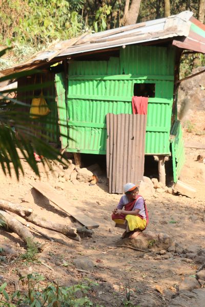
We have established ourselves for a few days in Agartala, capital of the Northeast Indian state of Tripura. There is not an awful lot to do here, but we take a few days, to recuperate from hectic Bangladesh. Not that Indian cities are not hectic, but our small guest house, where we are the only guests, is an oasis of peace.

Unakoti, outside Kumargath
23. Kumarghat and Unakoti
You have these days that everything works out just fine, very smoothly. We had been looking for hotels in Kumarghat earlier, but nothing came up on the regular booking sites. Via Google and Facebook – how could we ever have travelled without these, before? – we managed to get a phone number of a reasonably rated hotel, which we called to reserve a room. The response didn’t inspire a lot of confidence, but we booked anyhow. Perhaps the gentleman would want to know my name? Ahh, ok, tell me. My first name was enough. And transport to Unakoti, the site we wanted to visit? Ahh, we sort out when you get here. And how much is all this going to cost? Ah very little, Sir, very little.

Silchar
24. Silchar
Having arrived in Silchar, the second largest town in Assam state, effectively means that we skip the states of Mizoram and Manipur, two other NE Indian states with mesmerizing names, beautiful nature and tribal people – Kukis amongst them.

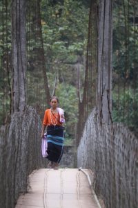
‘double-decker’ root bridge in Nongriat
25. Nongriat
From the capital of Assam state, Guwahati, where we took a plane to, to avoid either an impossibly bad road, or a 10 hour detour, we almost immediately left for Meghalaya, yet another one of the Seven Sisters NE India states. Meghalaya is located to the north of Bangladesh, we actually have seen it from the other side already.
Against our usual travel practice, we have engaged the services of a travel agency, to provide transport and accommodation, and some further suggestions on our planned itinerary.
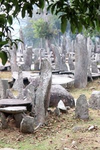
monolith park in Nartiang
26. Nartiang
There is more to Meghalaya then just the root bridges. They proudly promote the cleanest village of Asia – which, coming from The Netherlands, we skipped. Waterfalls and caves, hmm, we have seen those before, and they don’t necessarily excite us that much. There is the lake near Shillong, the state capital, which otherwise doesn’t seem to offer much. But what they hardly mention is a remarkable collection of monoliths, a place called U-Mawthaw-dur-Briew, or more simply, the monolith garden, near the town of Nartiang.

Guwahati
27. Guwahati
If Silchar was the second largest town in Assam, there is a huge difference between number two and number one. Guwahati is easily the biggest town in the North East, and it shows. Even though the spread of rickshaws and tuk-tuks seems to be controlled – there are far fewer here than we have seen so far in towns – the traffic is chaotic, not helped by several construction projects for fly-overs.

traffic signs
28. the traffic signs
Most of the time, in a car, I drive myself. Obviously, you look outside, try to appreciate some of the countryside, but mainly, you pay attention to the traffic. And to the traffic signs along the road. Perfunctorily. That is to say, you register the signs, you know what they are supposed to tell you – but you don’t really look in any detail.

on the way to Tawang
29. the road to Tawang
We leave Assam behind for the next NE India state, Arunachal Pradesh, home to the largest Buddhist monastery in India, Tawang. We plan to cover the distance, some 430 kms, in two days, also because we climb from Brahmaputra level to around 3100 m, deep in the Himalaya mountains.
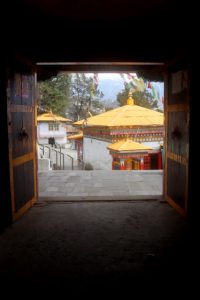
the Tawang monastery
30. Tawang
Except that there turns out to be another road to Tawang. Since a few years, there is also a Sela tunnel. And the tunnel is open. Until now, that had not been worth mentioning.
So after having come down a bit from the road to the pass, which we found closed, we take a turn and start ascending again. To reach the tunnel, without any issues, in another hour, or so. Only to drive straight into the clouds, on the other side. Which stay with us, for most of the road down to Tawang, where we, once again, arrive at seven pm, in the dark. Another long day. And it is so cold!

the senseless war in 1962
31. the 1962 Sino-Indian War
I am not going to analyse the Sino-Indian war of 1962 in great detail. In short, parts of the border between China and India have been, are still being disputed, and an important part of the dispute is the border in Arunachal Pradesh. In this area, in particular, the Chinese maintain that Tibet had no right to cede territory, including the area around Tawang, to the British at the 1914 Simla Convention; British India later turning into present day, independent India.

appraoch to the Sela Pass
32. the Sela Pass
Tawang is end of the road, sort off, from here you can only continue to China, and that is obviously out of the question. So we need to track back to Dirang, again. This time we cross the Sela Pass.

Sangti, a village near Dirang
33. Dirang
There is not an awful lot to do in Dirang, where we landed again on the way back from Tawang. A small commercial district, referred to as the market, contains some 10, 15 shops, many selling the usual general supplies, and recognisable from the strings of salty crisps outside. Some sampling has actually revealed that most of those are uncannily spicy. And Dirang has its own monastery, the Thupsung Dhargye Ling monastery, a modern structure and – of course – nothing compared to Tawang.
the Loser festival in Dirang
34. the festival
It happens to be Tibetan New Year, called Losar. And this is celebrated in Dirang for all the villages in the surrounding, many of which have sent their traditional dance groups to the festival. The groups are small, perhaps four of five people each, but all have been dressed up, with costumes, masks, and colourful hats. One group has brought a bull – the costume of a bull -, another two snow lions.

Bomdilla
35. Bomdilla
Bomdilla is a bit like Dirang. Quite some tourist infrastructure, in the form of hotels, homestays, and restaurants – which, confusingly are also called hotels, but for ‘fooding’ only. Yet, there doesn’t seem to be a lot to do in town. There is the market, in Bomdilla’s case the old market and the new market, i.e. no less two commercial streets. A rather modern monastery, the Gontse Gaden Rabgye Ling, is even less impressive than the one in Dirang, although a second Buddhist temple in town, Thubchog Gatsel Ling, looks a little nicer.

the mountain road to Ziro
36. the road to Ziro
Our next destination in Arunachal Pradesh is Ziro, further east. Most people would probably drive down to Brahmaputra level, the plains of Assam, follow the river upstream and then turn north again, to reach Ziro. But I manage to convince our driver to take an alternative route, through the mountains, which may take a little longer, but avoids the ugly, traffic-congested plains. Good move!

Ziro
37. Ziro
The small town of Ziro is actually a conglomeration of small towns; there is Old Ziro, and Hapoli, a newer market area, all very lively. Unfortunately, we have once again a guest house which is miles out of town – one of those things you have little control over, if you let someone else organise your trip. We take a stroll over the fresh products market, which is bigger than we have seen in a while. And with yet again unexpected finds, like bamboo shoots kept in large plastic bottles, and a flat basket full of silk worms, still alive, apparently a real delicatesse here.
the road to Majuli
38. to Majuli
We leave Arunachal Pradesh behind, and return to Assam, and the plains dominated by the Brahmaputra. The descent goes via the Ranganadi dam, in the river of the same name, and then on a relatively small road, which more or less follows the Ranganadi down. Verdant green, jungle-like vegetation, lots of bananas again, and very few villages.

the Dejoo Tea Estate
39. the tea plantation
Five minutes into Assam – which indeed is well known for its tea – we stumble upon the Dejoo tea estate. And not only that, the plucking is in full swing, and literally hundreds of women, only women, are moving in between the tea bushes to harvest the top leaves. It is exactly what you want, approaching a plantation. The bright green colour of the tea, and the multiple-colour dressed harvesters, rising above the tea plants.

the boat driver of the ferry
40. the ferry
There is no bridge to Majuli, the island where we are heading. Not yet, but the traces of construction are everywhere, from the construction of a new, much wider road, to the pillars that will support the bridge in the future. But for the time being the only way to cross to Majuli is by ferry.

Majuli Island
41. Majuli
Majuli is the biggest riverine island in the world (although there is some competition with an island in Brazil, depending on exact definitions). But the question is, for how long? At the beginning of the 20th Century the size of the island was over 1200 km2, which has reduced to under 400 km now, due to erosion by the Brahmaputra. There are surveys that suggest that the island may disappear in its entirety in the next 15 or 20 years – although efforts are underway to counter erosion by planting large forests.

pottery village Falmora, on Majuli Island
42. the pottery village
I have seen village pottery making before, on my travels. But never was I so fascinated by the process as here in Falmora, a specialist pottery village on Majuli Island. Especially the bakery of the pots is great. On a small hill, a mountain of pots is created by stacking larger and smaller pots densely together, the pile occasionally supported by wooden sticks.

Samaguri Satra, a mask making centre on Majuli Island
43. the mask makers
The craft of mask making was established in the 15th or 16th C, when the monks of the satras on Majuli felt the need to connect to the masses. They did this through theatrical performances, whereby masks were worn to represent mythical characters. The tradition has been kept alive, and today there are four satras who make masks, from life size heads that fit on a man’s head to larger animal creatures that are moved by wires. The most famous one is the Samaguri Satra, where the chief mask maker, a monk, resides with his family, many of whom are also involved in the production process.

Numaligarh
44. Numaligarh
Back on tierra firma, having arrived at the Nimati Ghat on the south bank of the Brahmaputra by much larger ferry, we soon hit the Assam Trunk Road, the main east-west throughfare.

Kaziranga National Park
45. Kaziranga
Tawang may have been touristic, and the Ziro Valley, and Majuli. But with Kaziranga National Park we have reached a new dimension. A UNESCO World Heritage Site, this game reserve is especially known for it being the only place in the world for the one-horned rhinoceros. And there are quite a lot of them, together with elephants, sambeer deer and hog deer, wild boar and lots of birds. And the ever elusive tiger, of course.

Sibsagar
46. Sivasagar
We backtrack from Kaziranga east again, along the Assam Trunk Road. In places this is a two-lane road – which, as so often in India, is being used as three-lane, at least, and with involvement of motorbikes and tuktuk easily four-lane. In other places it is a proper four-lane motorway, with separation in the middle. Which means that motorbikes and tuktuks, and even the occasional car, come straight at you, against the traffic, if they only need to move a short distance.
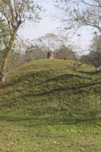
burial site of Charaideo
47. Charaideo
We keep what we think is going to be the absolute highlight for last. There are some 386 moidans – burial mounds – in 137 locations in what used to be the Ahom kingdom along the Brahmaputra river in Assam. The most important of those, of the Ahom royals – recently recognised as a UNESCO World Heritage site – are located in Charaideo, the first Ahom capital, some 30 kms from Sibsagar.

Kohima
48. Kohima
As soon as we leave the plains of Assam and enter the mountains to the south, we know we are in Nagaland. We are supposed to show our permits again – for Nagaland we need an Inner Line Permit, an ILP, much easier to obtain that the PAP for Arunachal Pradesh. But there is no police or border post, no great big book to write our data in, and we enter, undetected! to Nagaland’s capital city, Kohima.

village outside Kohima
49. around Kohima
Kohima is located on a couple of hillsides. As soon as you leave the city, you are confronted with the rice paddies and vegetable terraces that surround the town, a fabulous sight. Every river valley is built up from below, up the slope, with terrace after terrace, interspersed with little huts for shelter, or for tool storage. Most paddies are dry, at this time of the year, but some contain water, although the luxuriant green colour of the rice is absent. Unfortunately, it is a bit hazy, obscuring the views somewhat, but still, very enjoyable.

Pfutsero
50. around Kohima (2)
We reach as far as Pfutsero, a town some 80 km from Kohima, and allegedly the highest and the coldest town in Nagaland, at some 2100 m (I presume there are villages higher than that). Which is a bit of a disappointment, because you come to Pfutsero because of the expansive views over the valley and the mountains, which were virtually invisible because of the haze.

to Mokokchung
51. to Mokokchung
We drive from Kohima to Mokokchung on a Sunday. Yesterday’s busy commercial centre is now abandoned, all the shops are closed, and the only people on the road are those who, well-dressed, make their way to church. Outside town, in the villages we pass, it is the same: everything closed, and now not a soul on the road – obviously the church services have started. It is a strange experience, as if driving through a ghost town.

Mokokchung
52. Mokokchung and the Ao villages
The centre of Mokokchung is rather underwhelming, a few streets with shops, the occasional restaurants, and a church or two – this is Baptist territory, no competition. There is the meat market, the football stadium, and even a real piece of modern art, a sculpture made of used car parts. And it has the Whispering Winds hotel, by far the best accommodation we have experienced so far on this trip.

Ao village of Longkong
53. Mokokchung and the Ao villages (2)
There are a few villages left, still. One is Mopungchuket, a village like all others, except that it has the name to be somewhat of a tourist attraction. Not that there are any tourists at all, no, no, but the village has a museum! With a ticket booth. Not that there is anybody to collect the entry fee, but we’ll deal with that on the way

the road to Longwa
back.
54. the road to Longwa
Although distances aren’t very large, between towns in Nagaland, the quality and the design – winding up and down mountain slopes – of the roads is such that driving takes a long time. From Mokokchung to Longwa is less than 200 km; yet, it takes us a full day. But, as almost every day, we enjoy the natural beauty of the hills, the lush vegetation.

the king’s palace in Longwa
55. Longwa
Longwa is a curious village. At some 1500 m altitude, it is right at the border with Myanmar; in fact, the king of Longwa has jurisdiction over some villages in India, but also over Konyak people living just across the border in Myanmar. Which is why the king’s palace is half in India, and half in Myanmar.

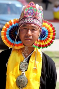
the Aolyang Festival in Longwa
56. the Aolyang festival
The annual Aolyang festival of the Konyak tribe in Longwa celebrates the start of a new year, linked to the growing season. It is a six-day festival, for which the people dress up in traditional gear. Men and women.

Sheanghah Chingnyu village
57. Sheanghah Chingnyu
As the festival in Longwa is finished, at least the public part of it – the villagers themselves party another three days, but privately, in families and clans – we spend the next day in another village, Sheanghah Chingnyu, where Aolyang is celebrated a day later.
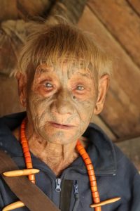
one of the tattooed headhunters
58. the head hunters
One of the issues I have not yet discussed in great detail, is the head hunting history of the Naga, and especially of the Konyaks, who were apparently the fiercest, and who continued longest, probably well into the 1960s.

Dibrugarh
59. Dibrugarh
The day we leave Nagaland, there is another festival, in Mon, but we have to move on. Even we don’t have all the time of the world. As instructed, we check out with the Mon police, most of whom are obviously also at the festival, and we drive out of the mountains to the plains of Assam, again. To Dibrugarh.

Siliguri
60. Siliguri
Our arrival in Siliguri could not have been timed worse. Today is Ram Navami, the Hindu festival that celebrates the birth of Lord Rama. The entire city is coloured orange, from large and small flags, from garlands across the roads, from people’s dresses. Dutch football supporters could learn a thing or two.

the Toy Train between Siliguri and Darjeeling
61. the Toy Train
Siliguri, or rather, nearby New Jalpaiguri Junction, is the starting point for what is commonly known as the Toy Train, a narrow gauge railway that runs between Siliguri and Darjeeling. And climbs from 120 meters above sea level to more than 2000.

Darjeeling
62. Darjeeling
A large part of Darjeeling occurs around the railway station, where the Toy Train arrives and departs. On the opposite side of the road is the Loco shed, where the different engines are kept, many of which are steam engines. There are quite a few trains, not just the once a day connection with Siliguri, but also many for what is called joy rides, shorter trips that explore the track close to Darjeeling.

Gangtok, capital of Sikkim
63. Gangtok
To get from Darjeeling to Gangtok, in Sikkim, the only form of public transport is the dreaded Sumo, the jeep that fit ten passengers, kind of. Two rows of four, and two in the passenger seat next to the driver. We buy four seats next to each other, a whole row, and so travel unexpectedly comfortable.

Kolkata
64. Kolkata
Somehow I always had the impression that Kolkata – or Calcutta, as it used to be called – is the most chaotic Indian city of all. The old centre of Delhi was busy, when we lived there 20 years ago, and Mumbai, I recall, was a nightmare negotiating. And on this trip we experienced Guwahati, a traffic mess because of its many construction projects. But I was convinced that all of this would pale into insignificance by what we would encounter in Calcutta. It didn’t.

flower market in Kolkata
65. Kolkata (2)
Another thing we have always associated with Calcutta is its artistic credentials. All the artists we knew, and knew of, 20 years ago, were Bengali, so it cannot be other than that Calcutta is the capital of Indian art, at least its modern and contemporary art.
The first signs are indeed positive, I discover the KMOMA, the Kolkata Museum of Modern Art, no less than nine stories, and a fabulous building. At least, the artist’s rendition looks fabulous, but as it turns out the construction, started in 2013, hasn’t been finished yet. Or maybe it hasn’t even started.
looking back on NE India
66. looking back on NE India
Having lived in India 20 years ago, we consider ourselves experts on the subject. But then, we never went to the Northeast, that part squeezed in between Bangladesh and Myanmar, until not so long ago unknown territory. Now there are two possibilities: either India has changed beyond recognition, in the past 20 years, or the Northeast is really very different from the rest of India.


